🇯🇲 SUNKEN PIRATE CITY AT PORT ROYAL
🇯🇲 SUNKEN PIRATE CITY AT PORT ROYAL
“The earth opened and swallowed many people, before my face, and the sea I saw came mounting in over the wall, upon which I concluded it impossible to escape.”
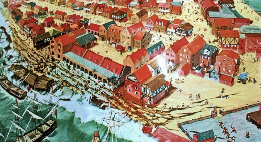
Edmund Heath, survivor and eyewitness to the devastating 1692 earthquake wrote these words in a letter from the safety of a ship moored in the city’s harbor, overlooking the ruins of his city. Port Royal, once called “the most wicked and sinful city in the world” was famous the world over for its booze—the blackout-inducing Kill Devil Rum, its pirates, and its sex workers. Needless to say, when the city was nearly destroyed, there were some parties that saw it as a convenient solution to an ugly problem.
The English and their pirate friends were relatively new to the area. Jamaica had been held by the Spanish since Columbus first declared it “the fairest island eyes have beheld” in 1494. Lacking gold or other obvious exploitable wealth, the Spanish held it but did not focus much energy there. It came under English power in 1655, after Cromwell sent English raiders to invade and capture the Spanish stronghold at Hispaniola (now Haiti and Dominican Republic, then the center of Spanish trade in the Caribbean). Cromwell’s men failed spectacularly at taking Hispaniola and turned to Jamaica as a second choice, better-than-nothing option.
Located on the southeast coast of Jamaica, the natural harbor at Port Royal became the center of English life in Jamaica. By the late 1600s it had become one of the largest European cities in the new world, second only to Boston. It had also become the infamous home of pirates, sex workers, and Englishmen on the make. Far from home, they made their livings off of the slave trade, slave labor in plantations, and the money that the pirates brought in from their looting forays against the Spanish.
It may be seen as an indicator of the caliber of vice in Port Royal that in 1675 the notorious pirate Henry Morgan became the Lieutenant Governor. In fact, Morgan began to crack down on overt piracy as the grand era of privateering he had been part of began to enter its waning phase. He died just four years before the earthquake struck and was buried in the Palisadoes cemetery.
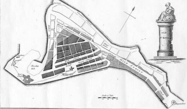
On the morning of June 7, 1692, a massive earthquake estimated at a 7.5 magnitude hit the island. The city, largely built over sand, suffered instantly from liquifaction, with buildings, roads, and citizens sucked into the ground. Geysers erupted from the earth, buildings collapsed, and finally the city was hit by tsunami waves, dragging what had not been destroyed out to sea. In the end, some 33 acres of the city disappeared under water, four of the five forts were destroyed or submerged, and 2000 people were killed. The cemetery where Captain Morgan was buried slipped into the sea, its bodies floating up to mix with the freshly dead.
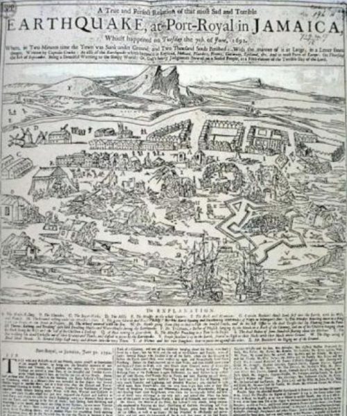
Even before the earth stopped shaking, locals reported that the looting began, one writing: “Immediately upon the cessation of the extremity of the earthquake, your heart would abhorr to hear of the depredations, robberies and violences that were in an instant committed upon the place by the vilest and basest of the people; no man could call any thing his own, for they that were the strongest and most wicked seized what they pleased....”
As news spread of the destruction of Port Royal, it was picked up as a cautionary tale and a sure sign of divine retribution for the lewd behavior of the pirates and sex workers, the pretensions and wealth of the gentry of the town, or the sins of slavery, depending on the city and the audience.
But at any rate, the earthquake did not end Port Royal’s wicked ways, nor its relationship with vice or with pirates who continued to stop by for another 50 years while they preyed on Spanish ships. In fact, in 1720, John “Calico Jack” Rackham was hanged at Gallows-Point in Port Royal by order of pirate hunter—and former privateer—Woodes Rogers (best known for his rescue of the castaway Alexander Selkirk, the inspiration for Robinson Crusoe).
Since then the city has been racked by fire, earthquake, and hurricane several times. The English finally decided to close its naval station at Port Royal, effectively closing it for business, and most residents left. In 1951, what was left of Port Royal was hit by Hurricane Charlie, destroying more property and leaving only a few of the original buildings standing.
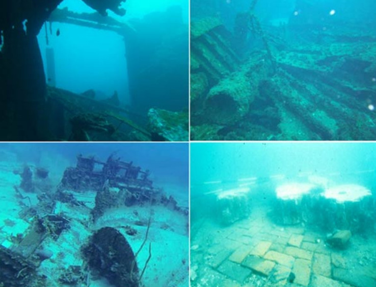
Today most of the remains of the 17th century city lie under up to 40 feet of water. Up until the 1900s visitors reported on the city still visible below the waves and the eerie sensation of floating over the rooftops. Since the 1950s, divers have been exploring and cataloging the submerged city. In 1969, Edwin Link discovered the most famous artifact: a pocket watch dated 1686, stopped at exactly 11:43.
More recently the Nautical Archaeology Program at Texas A&M University and the Jamaica National Heritage Trust conducted underwater archaeological examinations, ending in 1990. Their explorations have brought to light artifacts of 17th century life rarely seen. Because of the nature of the disaster, which left many buildings intact and more or less undisturbed, it has been compared to Pompeii for its archaeological wonders and was a designated National Heritage Site in 1999.
Special access from the government is required to dive in the restricted Port Royal ruins area, but many of the items recovered over the years can be seen at the Museums of History and Ethnography at the Institute of Jamaica in Kingston.
source atlas obscura
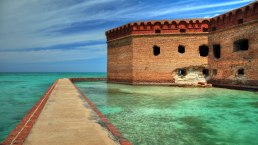
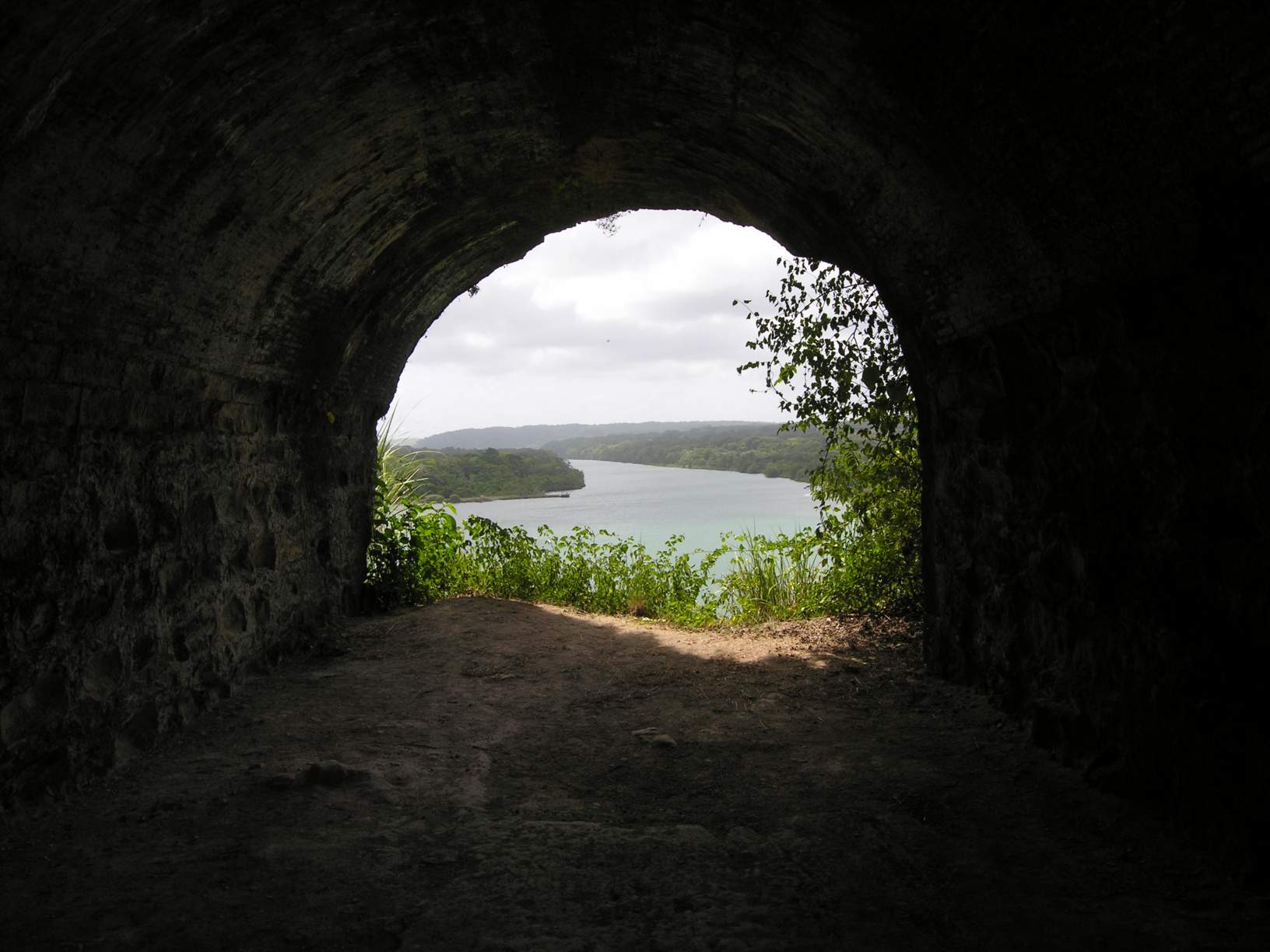
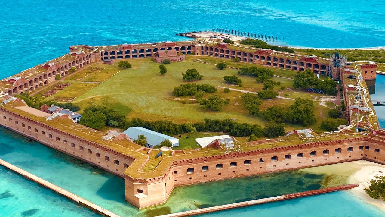
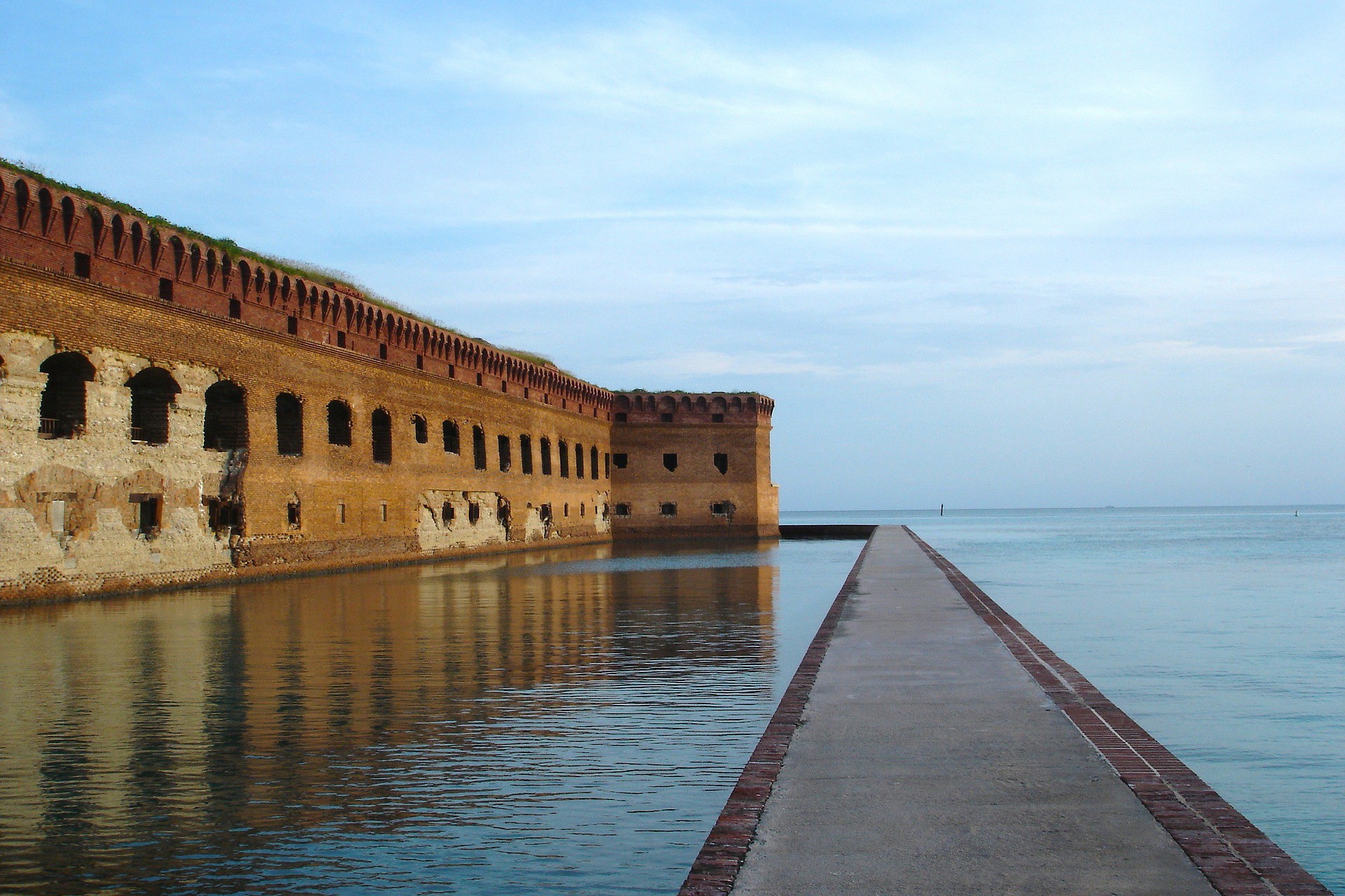
🇺🇸 Fort Jefferson
🇺🇸 Fort Jefferson - Dry Tortugas
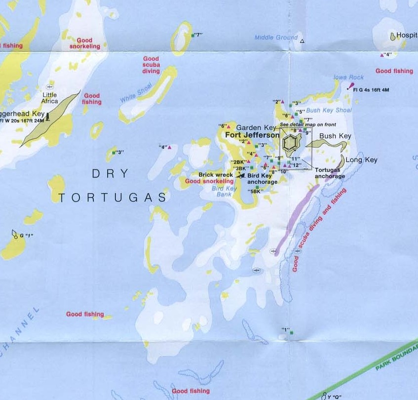
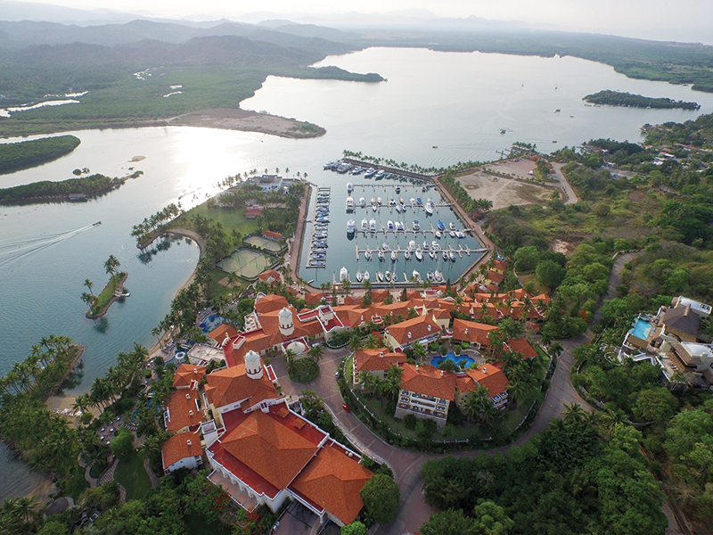
Bird Key Anchorage @ 24° 37.3033' N 82°52.7833' W
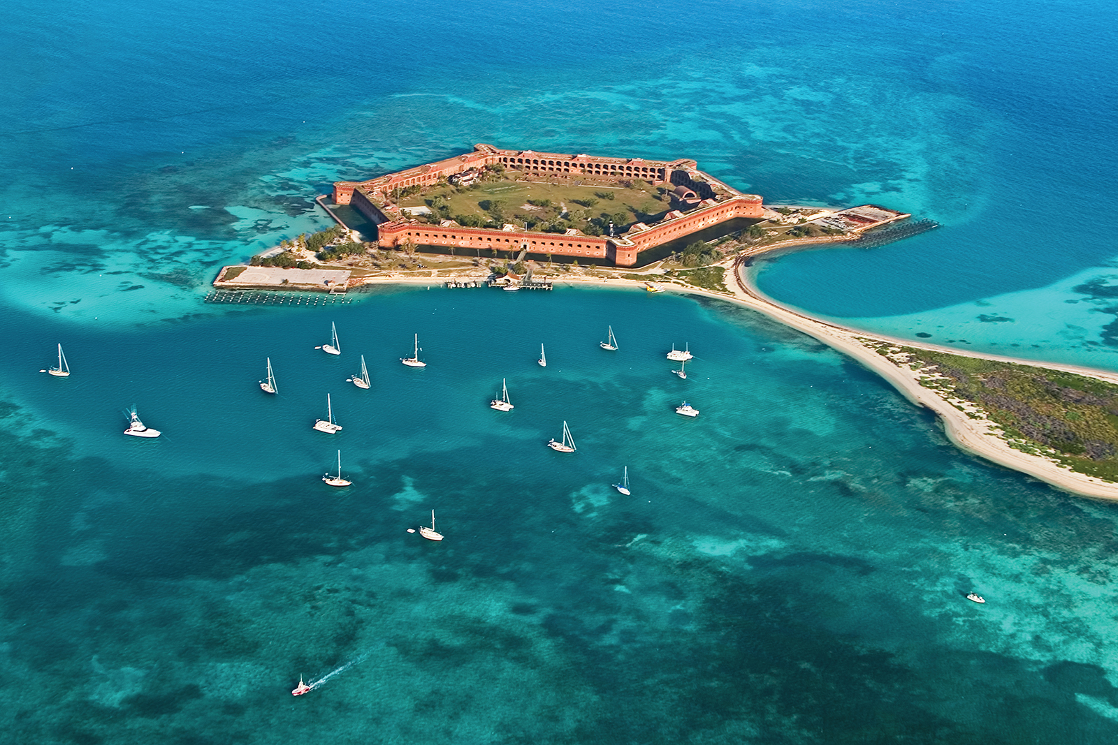
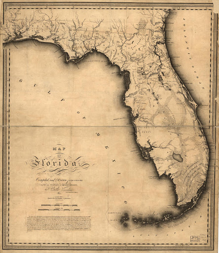
Dry Tortugas and Fort Jefferson lies about 60 nm due west of Key West
In 1513, Ponce de León led the first known European expedition to La Florida, which he named during his first voyage to the area and discovered the islands in 1513 and named them for the tortoises (Spanish tortugas) that abounded there.
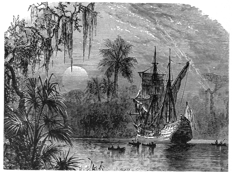
In 1521, Ponce de León returned to southwest Florida with the first large-scale attempt to establish a Spanish colony in what is now the continental United States. However, the native Calusa people fiercely resisted the incursion, and he was seriously wounded in a skirmish. The colonization attempt was abandoned, and died from his wounds soon after returning to Cuba.
In 1821 Spain sold Florida to the United States for $5 million (Florida Purchase Treaty which remained in full effect for a whopping 183 days) and about 5 years later lighthouse was constructed on Garden Key in the dry Tortugas
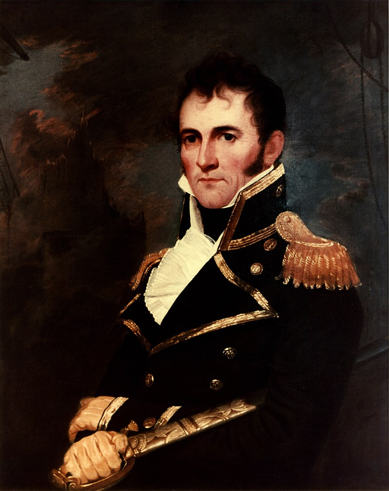
During that time U.S. Navy Commodore David Porter inspected the Dry Tortugas island
s as he was on the lookout for a site for a naval station that would help suppress piracy in the Caribbean.
While Commodore Porter thought the Dry Tortugas were unfit for a naval station. He commanded a number of U.S. naval ships, including the famous USS Constitution and saw service in the First Barbary War. Porter was later court martialed and resigned and then -
joined and became commander-in-chief of the MEXICAN NAVY and inspired the songs "Hey Joe" and "I'm on the Mexican radio" (bad joke)
In 1829, under recommendations from Commodore John Rodgers, the survey ship Florida stopped at the Dry Tortugas to evaluate the anchorage. Contrary to Commodore Porter's experience, Josiah Tattnall was delighted with what he found. It consisted of 11 small keys and surrounding reefs and banks, over which the sea broke. There was an outer and an inner harbor which afforded a safe anchorage during all seasons and was large enough to let a large number of ships ride at anchor. The Dry Tortugas would constitute the advance post for a defense of the Gulf Coast.
300 years after Ponce's discovery it was of course prisoners, soldiers and hundreds of slaves who built the park’s centerpiece Fort Jefferson which constitues the largest all-masonry fortification in the Americas and is the largest brick masonry structure composed of over 16 million bricks. At 400 bricks per day it takes a lot of manpower ( 40,000 days to be exact ) to build as this building covers 16 acres. Among United States forts, only Fort Monroe in Virginia and Fort Adams in Rhode Island are larger.

Enslaved African Americans were responsible for the most difficult tasks at Fort Jefferson. They labored ten hours a day, six days a week. Using little more than wheelbarrows they offloaded arriving ships. The 16 million bricks were used in the fort’s construction. Perhaps their most arduous task was collecting and transporting large quantities of coral rock from nearby islands. This coral material served as the main ingredient in forming coral concrete, a vital component in the fort’s construction. Several of the enslaved men were permitted to bring their wives with them. These women often served as cooks and laundresses
One amazing story is that of an escape covered in the underground railroad documentation
ESCAPING
Early on July 10, 1847, under the cover of darkness, seven freedom seekers named Jerry, Jack, John, George, Ephraim, Howard and Robert fled Garden Key. They took with them every vessel that could float, a brilliant move that greatly reduced the risk of being pursued and captured. Without being detected the seven men removed the schooners Union, Virginia, and b, and a small boat belonging to the Garden Key lighthouse keeper.
Soon after fleeing Garden Key and entering the Loggerhead Channel, they disabled and abandoned the Virginia, the Activa, and the lighthouse keeper’s boat by cutting and smashing their hulls. Their escape went completely undetected until daylight when the boats and men were reported missing. Minutes later the Union was spotted from the Garden Key Lighthouse. By 7:00 AM, the group had traveled fifteen miles, and were spotted three miles west of Loggerhead Key heading south.
THE PURSUIT
With Lieutenant H.G. Wright away on business in Key West, Dr. Daniel W. Whitehurst, his second in command, organized the pursuit. Because of the freedom seekers’ thoroughness, only one old condemned vessel, the Victor, remained near the island. Work on refastening and caulking the Victor began immediately, and within two hours the vessel was repaired and outfitted.
By 9:00 AM the repaired Victor started in pursuit. On board were eight men led by lighthouse keeper Captain John Thompson. Since there was no wind, oars were hastily made and the men began an exhausting chase. Four hours later they had closed to within three miles of the Union. The freedom seekers, after making several course changes, hauled down the jib of the Union, cut away both masts, and disabled the rudder. At approximately 2:00 PM they scrambled into a small boat from the Activa and began “pulling to the southward with great force.” On board they carried a compass, clothing, spyglass, axes, and a small barrel of water.
Thompson and his crew continued the pursuit for several more hours until they lost sight of the lighthouse. Concerned because of a rapidly developing storm, the crew of the Victor returned to Garden Key by midnight. As the weather continued to deteriorate, Dr. Whitehurst waited and pondered the fate of the escapees. Understandably impressed with the careful planning and execution of the escape attempt, he speculated that their destination was the Bahamas
The Capture
The seven freedom seekers survived the powerful storm, but their hazardous journey was only beginning. They traveled eastward through the Straits of Florida where they were spotted two days later by a local captain near the island of Key Vacas, nearly 120 miles east of the Dry Tortugas.
An alarm was spread on Key Vacas, and several vessels began chase. The following day the boat was discovered on the beach at Long Key several miles to the east. Coming ashore, the pursuers began firing their weapons in an effort to frighten the fleeing men. To avoid capture, the freedom seekers ran for the beach on the other side of the island, near Indian Key, and then desperately fled into the water. The chase finally came to an end as a boat from the sloop Key West picked the fleeing men from the water and took them to Key West.
After an exhausting journey, the men had ultimately failed in their quest for freedom. Two leaders in the group were returned to their owners, and the remaining five men were sent back to Fort Jefferson
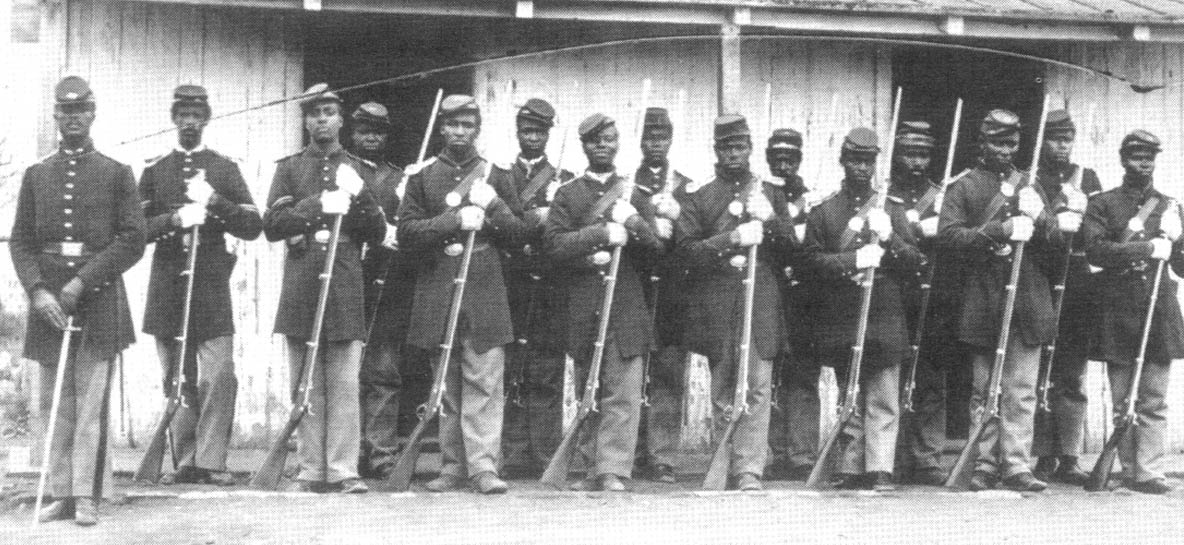
By 1863, with the arrival of hundreds of military convicts (sentenced to perform hard labor), the use of enslaved peoples was discontinued at this remote outpost. African Americans returned two years later, not in bondage, but as soldiers.
No longer denied their freedom, by 1865 African Americans had become the guardians of freedom.
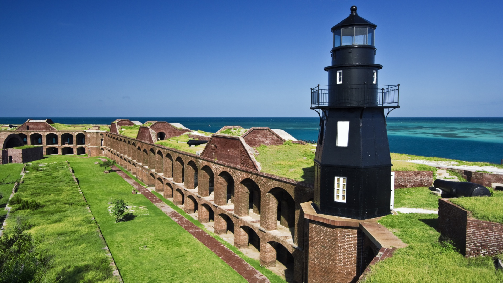
Although the fort was never fully completed, it remained active throughout the Civil War and later housed prisoners – mainly Union deserters until 1873 – before being turned over to the Marine Hospital Service in 1888. The area around Fort Jefferson became a National Monument in 1935, and finally a national park in 1992.
The park can be reached only by boat or seaplane. Its waters contain abundant and varied marine life, including three species of sea turtles. Thousands of migrating birds stop at or nest on the islands. For Birders of note is a large flock of sooty terns that nests on Bush Key each spring and summer.

HOW TO GET THERE
There are two routes from Key West, one running north of the Marquesas Keys, Half-Moon Shoal and Rebecca Shoal, and the other going to the south. Both routes are about the same distance and easy to navigate with sat chartlets and provide good protection.
A shallow reef completely surrounds the southern main anchorage, protecting vessels from waves, if not the wind. The bottom is marl, so use your big-boy anchor and a lot of chain to prevent dragging during high, sustained winds.
“Public visiting hours” are a good time to stay away and wait for the ferry and seaplanes to leave an important part of your daily Dry Tortugas routine, providing a fairly high-end but nominally-priced lunch buffet, ice-cold drinks, clean heads, garbage drop-off and freshwater showers!
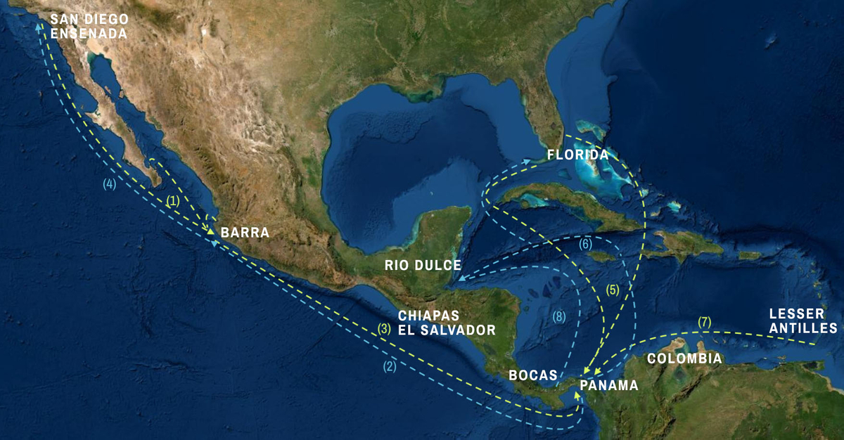
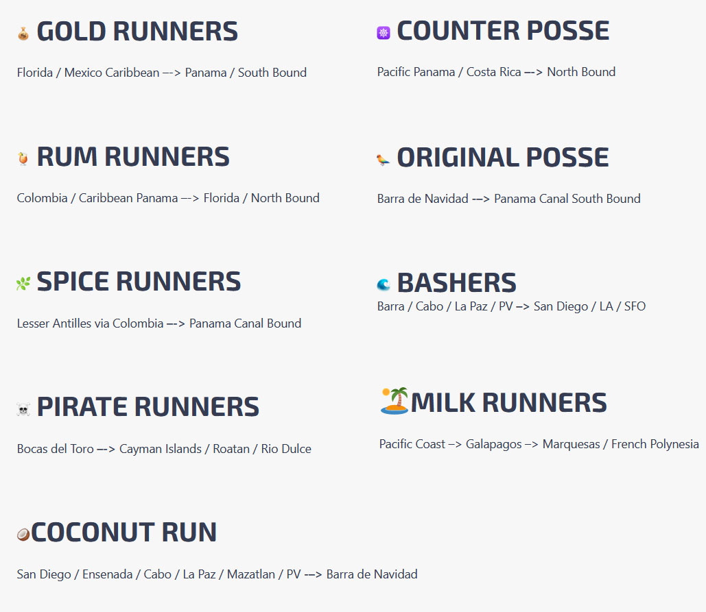
TO JOIN THE PANAMA POSSE WHICH FOCUSES ON FINDING INSPIRING DESTINATIONS FOR YOU AND YOUR VESSEL
SIGN UP FOR THE PANAMA POSSE
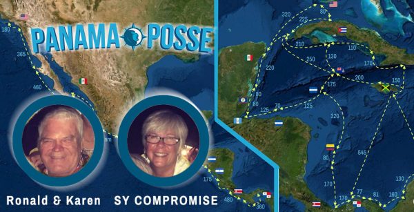
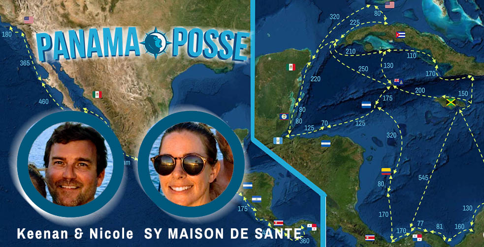
FLEET UPDATE 2020-11-01
![]()
THE 20·21 PANAMA POSSE FLEET IS GETTING UNDERWAY
FLEET UPDATE 2020-11-01
The Cruising season has started with vessel making way in the Pacific and Caribbean !
Panama Posse
Ronald & Karen approaching Acapulco, MX and meeting with Captain Vicente in Acapulco !To contact Capitan Vicente and get on hos moorings in Acapulco follow this link to Good Nautical >>Vicente 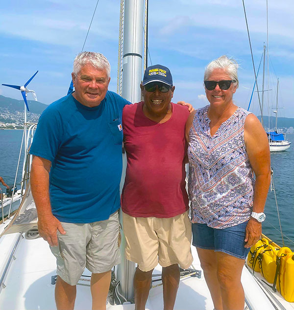
Kick Off Events confirmed Dec 3-7 th, 2020Barra de Navidad, Mexico
REMINDER THERE WILL BE A PANAMA POSSE POT LUCK RED CUP PARTY
**Here is a link to a list of which dishes you should/could bring >>>
** outside social distancing event rules apply as per resort and local authorities We'll be wearing masks this season for the kick off and hand sanitizer will be flowing along with rum and margaritas ...
Panama Posse Barra de Navidad HQ
CLIMATOLOGY
MARCH PAPAGAYOS
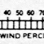
Wind roses are located in the center of each 5° square on the surface of the Earth on the oceans pilot charts and are published for each month. We have chopped these pilot charts to digestible portions into each Maritime Area. This exert above represents March for Nicaragua Pacific Coast. aka the Papagayo WInd Area.
Each rose shows the distribution of the winds that have prevailed in the area over a considerable period of time - think decades.
Wind percentages are summarized for calm (center) and for the Cardinal and Inter cardinal compass points.The arrows fly with the wind,indicating the direction from which the wind blew. |
The length of the shaft, measured from the outside of the circle to the end of the visible shaft (not necessarily to the end of the last feather), using the appropriate scale below, gives the percentage of the total number of observations in which the wind has blown from that direction.
The number of feathers shows the average force of the wind on the Beaufort scale. The figure in the center of the circle gives the percentage of calms. When the arrow is too long (over29 percent) to fit conveniently in the 5° square, the percentage is indicated numerically on the shaft.
WINDROSE

EXAMPLE: In this wind rose reported observations the wind has averaged as follows:
N 32 percent, Beaufort force 5
NE 11 percent, Beaufort force 4
E 8 percent, Beaufort force 4
SE 4 percent, Beaufort force 4
S 3 percent, Beaufort force 4
SW 5 percent,Beaufort force 4
W10 percent, Beaufort force 4
NW 25 percent, Beaufort force 4
Calms 2 percent
SCALE OF WIND PERCENTAGES:% SCALE OF WIND
BEAUFORT SCALE
0 Calm < 1 knot r Smoke rises vertically.
1 Light air 1–3 knots 0–1 ft Ripples with appearance of scales are formed, without foam crests Direction shown by smoke drift but not by wind vanes.
2 Light breeze 4–6 knots 1–2 ft Small wavelets still short but more pronounced; crests have a glassy appearance but do not break Wind felt on face; leaves rustle; wind vane moved by wind.
3 Gentle breeze 7–10 knots 2–4 ft Large wavelets; crests begin to break; foam of glassy appearance; perhaps scattered white horses Leaves and small twigs in constant motion; light flags extended.
4 Moderate breeze 11–16 knots 3.5–6 ft Small waves becoming longer; fairly frequent white horses Raises dust and loose paper; small branches moved.
5 Fresh breeze 17–21 knots 6–10 ft Moderate waves taking a more pronounced long form; many white horses are formed; chance of some spray Small trees in leaf begin to sway; crested wavelets form on inland waters.
6 Strong breeze 22–27 knots 9–13 ft Large waves begin to form; the white foam crests are more extensive everywhere; probably some spray Large branches in motion; whistling heard in telegraph wires; umbrellas used with difficulty. Gale pennant.svg
7 High wind, moderate gale, near gale 28–33 knots 13–19 ft Sea heaps up and white foam from breaking waves begins to be blown in streaks along the direction of the wind; spindrift begins to be seen Whole trees in motion; inconvenience felt when walking against the wind. 🚩
8 Gale, fresh gale 34–40 knots 18–25 ft Moderately high waves of greater length; edges of crests break into spindrift; foam is blown in well-marked streaks along the direction of the wind Twigs break off trees; generally impedes progress. 🚩
9 Strong/severe gale 41–47 knots 23–32 ft High waves; dense streaks of foam along the direction of the wind; sea begins to roll; spray affects visibility Slight structural damage (chimney pots and slates removed). 🚩 🚩
10 Storm, whole gale 48–55 knots 29–41 ft Very high waves with long overhanging crests; resulting foam in great patches is blown in dense white streaks along the direction of the wind; on the whole the surface of the sea takes on a white appearance; rolling of the sea becomes heavy; visibility affected Seldom experienced inland; trees uprooted; considerable structural damage. 🚩 🚩
11 Violent storm 56–63 knots 37–52 ft Exceptionally high waves; small- and medium-sized ships might be for a long time lost to view behind the waves; sea is covered with long white patches of foam; everywhere the edges of the wave crests are blown into foam; visibility affected Very rarely experienced; accompanied by widespread damage. 🟥
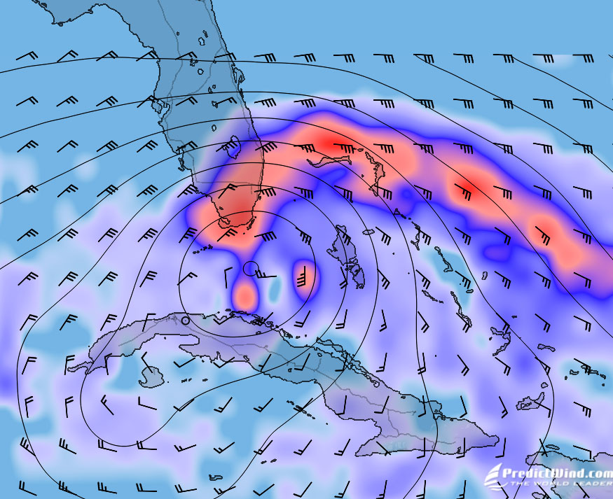
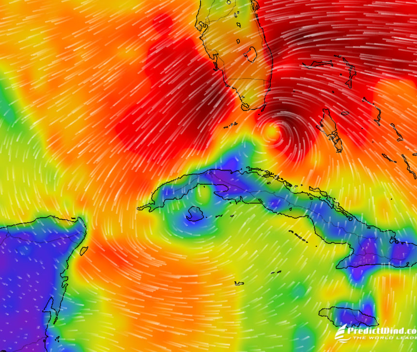
12 Hurricane force ≥ 64 knots ≥ 46 ft The air is filled with foam and spray; sea is completely white with driving spray; visibility very seriously affected Devastation. 🟥🟥 Lifting Winds behind a low could get you out of Panama Lifting Winds
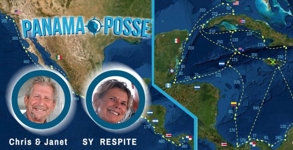
UPDATE FROM RIO DULCE - SV RESPITE
Wow not sure when The last time I had updated the Panama Posse.. Janet and I left the states on 10/15 heading back to the Respite in Belize. There has been lots of storms this year and Respite is sitting in the middle of hurricane zone. There was One direct hurricane hit where Respite was moored hurricane NANA. We were lucky Respite came out of it with some very minor canvas damage nothing that a sewing machine can’t fix. So our thoughts are we Needed to get Respite somewhere safe. The air port in Belize had opened to tourists 10/1 with LOTS OF REGULATIONS but we jumped at the chance.
Quite a journey, to make a long story short it was a two week process to get the proper paper work to take Respite to Guatemala. As we where hanging on anchor of courses other storm was brewing Zeta. It amazing Zeta was a couple hundred miles away and it differently affected the weather we’re we where. Enter Guatemala was some what normal check in process the only difference was we had to go to the hospital and have a Covid rapid test. It was rapid had results in about 10 minutes at no cost. Currently in the Rio Dulce at Monkey Bay Marina where we were last year. Have quite a few boat projects to complete and then start planning this season’s adventure. All is good a board Respite⚓️ Rio Dulce Rio Dulce Respite
PANAMA POSSE "PODS" ARE GATHERING pods PANAMA POSSE pods
💰 🍹🌿 ☠️ 🥥☸️ 🦜🌊 🏝️
Based on seasonal gathering spots here are the "sub pods" with line calls after the main calls starting Mondays in November to save everyone's time (great suggestion Eric Sprezzatura) Runners To add your designation to you LINE display name simply edit your display name using the GEAR icon within LINE and copy and paste or insert your EMOJI
WEEKLY LINE CALLS MONDAYS @ 15:30 UTC for CARIBBEAN 16:00 UTC for PACIFIC line.me

NEED CREW ? We have been receiving crew submission so if you are vessel in need of crew for the Panama Posse please let us know and we'll forward you these crew seeking vessel requests - go to https://panamaposse.com/crew and sign up as a Panama Posse vessel seeking crew. The crew section also displays mayor airports and has tips on what makes good crew. Please note if crew "jumps' ship" in a foreign port you are responsible for re-repatriation flights so we recommend establishing a crew bond. Crew
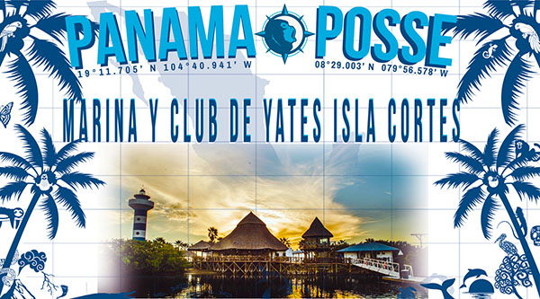
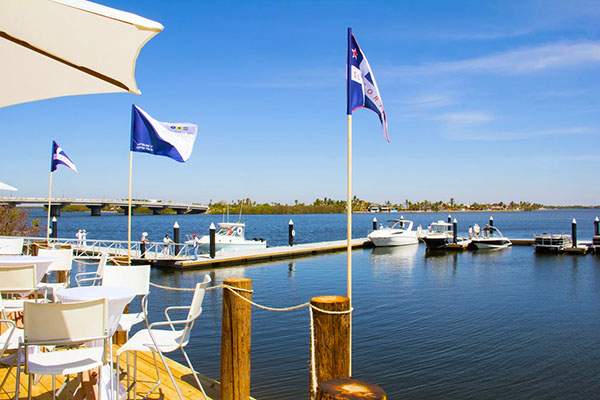
PANAMA POSSE INTRODUCES THE 40th SPONSORSHIP MARINA 🇲🇽 MEXICO - MARINA Y CLUB DE YATES ISLA CORTES .. find out more >>>
SAVE AND SHARE YOUR ROUTES
Please record all tracks in either your chart plotter or opencpn and email them to us for integration in to Good Nautical's route Library - for extra bonus save a NMEA 0183 data stream... We'll go over this in the OPEN CPN Seminar in early December >>>
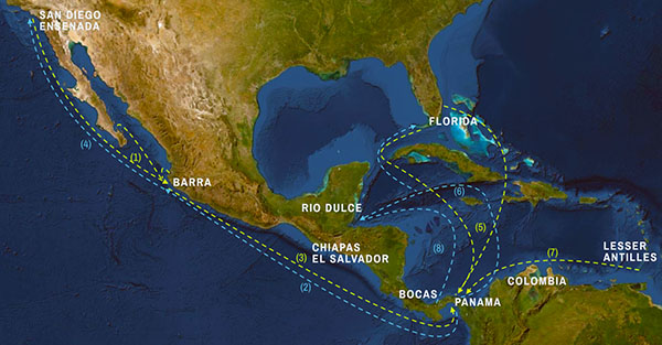
MUST VISIT PLACES ON THE PANAMA POSSE ROUTE >>>
https://panamaposse.com/castillo-de-san-felipe
🇬🇹 CASTILLO SAN FELIPE ... learn more ... >>>
NEARBY 🇬🇹 MARINA NANA JUANA RESORT & BOATYARD – RIO DULCE - GUATEMALA
>>> 15°39.508′ N 088°59.5833′ W
SEVEN SEAS CRUISING ASSOCIATION & PANAMA POSSESIGN STRATEGIC PARTNERSHIP AGREEMENT
FOR IMMEDIATE RELEASE
Nov 1, 2020
The SEVEN SEAS CRUISING ASSOCIATION is pleased to announce our collaboration with the PANAMA POSSE. Seven Seas Cruising Association (SSCA) has supported passage making sailors on their adventures around the globe since 1952. Visit ssca.org.
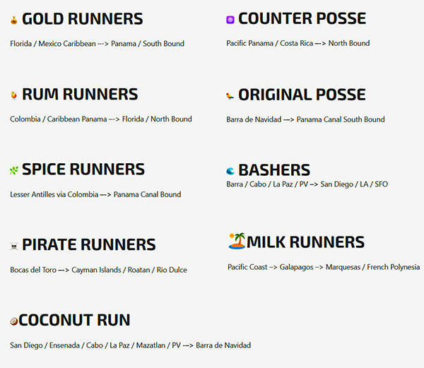
The PANAMA POSSE is honored to partner with the prestigious Seven Seas Cruising Association. We know this collaboration will strengthen our mutual goals to promote safe cruising adventures around the world. The Panama Posse was founded in 2017 to help boats navigate the Pacific coast from California to Panama at your individual pace. In 2020, the Panama Posse grew it’s route support to 13 countries, pass the Panama Canal to Key West including Jamaica, Belize, Colombia, Cuba, and Cayman Islands. Over 375 motor and sailing vessels have participated in the past 3 years and they all agree the best value in joining the Panama Posse is the camaraderie of meeting amazing people throughout your route. The Panama Posse also provides 24/7 access to members, weekly team calls, Up to date customs information, 2,000 verified anchorages and marina discounts in each country totaling 40 marinas. Visit PanamaPosse.com for additional information.
We are excited to see so many cruisers head south, down the Mexico coastline, Central America and through the Canal to South America, the Caribbean and Cuba. Along with safety seminars, and the marina discounts that the Panama Posse provides its cruisers, SSCA can go farther to help cruising sailors on the rally and beyond the rally with webinars, a Facebook page that has over 13,000 followers, introductions to our Cruising Station Hosts around the globe and discounts at our many marine partners and sponsors.
Membership in SSCA is always a great deal, but for a short time, membership will be discounted for registered Panama Posse participants by 25%*.
Visit SSCA.org for more information >>>.
As part of the strategic partnership the Panama Posse has extended a special discount to members of the Seven Seas Cruising Association, SSCA members receive 25%* off the annual registration fee of the 20-21 Panama Posse .
(*may not be combined with any offer does not apply to existing membership or registration fees )
https://www.ssca.org/content
QUARANTINE UPDATES COLOMBIA CLOSED ETA DEC 1
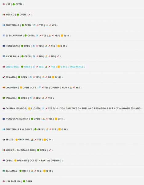
How to not loose your mind. Keep checking this section for most recent updates ...more >>>Quarantine
NOT PART OF THE 20·21 POSSE ?
SIGN UP FOR NEXT SEASON !
129 VESSELS HAVE SIGNED UP ALREADY >>>

WHERE IS YOUR HEADSHOT ? SEE WHO IS ON THE ROSTER >>>
PANAMA POSSE FACES of the 2020-2021 Rally
CHARTS WILL BE WRONG !
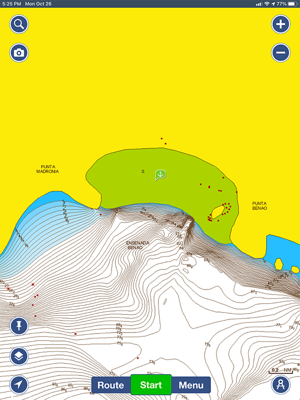
IN CERTAIN AREAS ALONG THE ROUTE
YOU WILL NOT BE ABLE RELY ON CHART ACCURACY
One of the reasons we recommend you familiarize yourself with OPENCPN with sat chart overlays ( covered in the kick off seminars in December)
HERE IS A SAMPLE OF THE NAVIONICS CHART
WRONG CHART
"You've been to this anchorage and documented it on Good Nautical! Right before Punta Mala. I was reminded of you doing a navigation meeting soon for Posse people and thought this to be a candidate for error example. A benign one fortunately. The lat/lon seems to be correct. From Navionics on ipad, recently updated. To avoid confusion use multiple sources!
Ensenada Venao
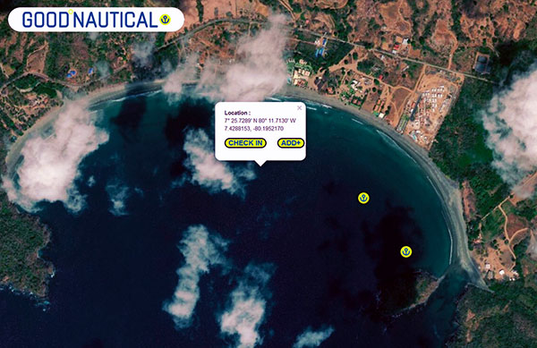
Accurate prior history anchorage information in Good Nautical Ensenada Venao >>
VAGABUNDO DOS
GOOD NAUTICAL NEEDS YOUR SUPPORT
The goal for this season is $ 50,000 and Good Nautical is a bonafide 501(c) non-profit organization so please add us to your holiday donation list.
We know that some of you are seeking year end TAX deductions and GOOD NAUTICAL is here to preserve and safeguard nautical knowledge.
GOOD NAUTICAL'S EIN: 83-1649603 for verification with the IRS ...>>>
MAKE A TAX DEDUCTIBLE DONATION NOW
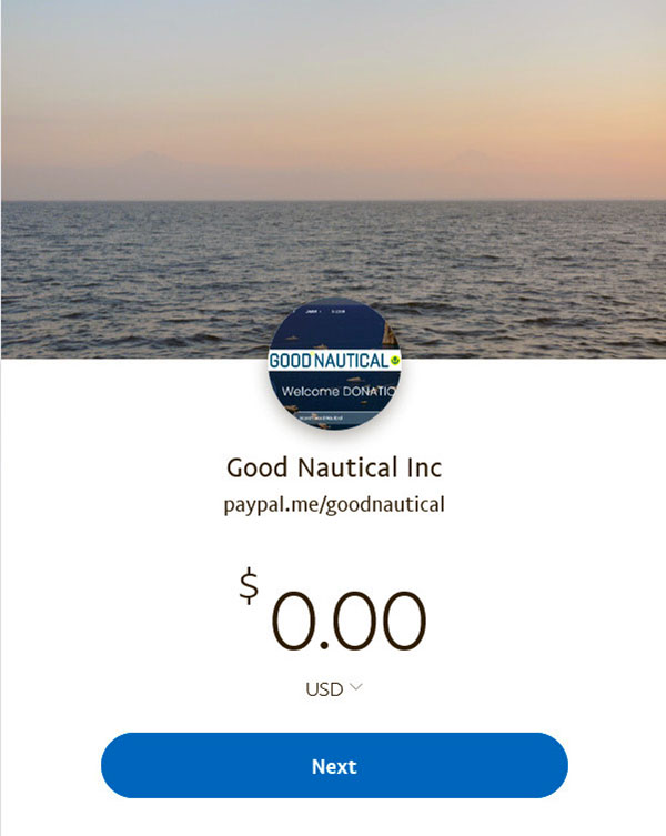
https://www.paypal.me/goodnautical
MAKE A TAX DEDUCTIBLE DONATION IN YOUR NAME
PLEASE MAIL A CHECK TO GOOD NAUTICAL INC. 9811 W. CHARLESTON BLVD SUITE 2-262 LAS VEGAS, NV 89117 or donate via PAYPAL https://www.paypal.me/goodnautical
Marinas
PANAMA POSSE PARTICIPANT WEBSITES
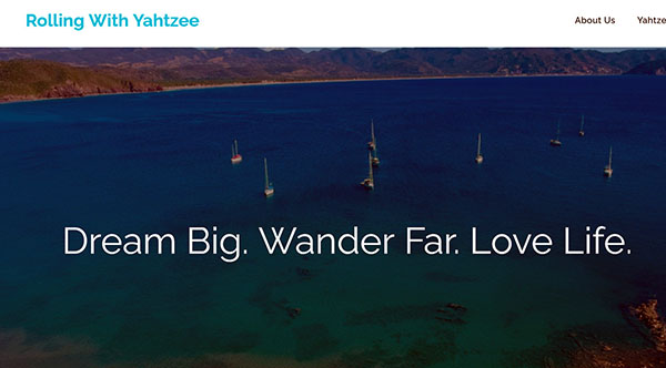
SY YAHTZEE
Here is the link to Past and Present Participant Websites and Blogs.
Lot's of goodness here ...more >>>
PICTURE OF THE WEEK
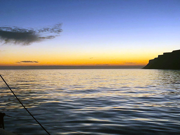
SY BEATA SUNSET ON THE BAJA PENINSULA
PICTURE OF THE WEEK BEATA

IT WOULD NOT BE A RALLY WITHOUT A CONTEST
by the end of May 2021 we will announce the winners in these highly competitive fields
BIGGEST FISH CAUGHT
HIGHEST WIND RECORDED
BIGGEST MISHAP aka THE CAPTAIN RON AWARD
MOST UNWELCOME VISITOR ONBOARD
SPEEDY GONZALEZ AWARD
PANAMA POSSE YODA OF THE YEAR
PICTURE OF THE YEAR
GOOD SAMARITAN OF THE YEAR
GALLEY GOD(ESS) - DISH OF THE YEAR (AWARDED DURING KICK OFF WEEK)
https://www.novamarinsurance.com/#
NOVAMARSPONSORS THE PANAMA POSSE
Spheric Assurance Company has expressed interest in insuring certain
Panama Posse Vessels Boats which fall in these categories
Minimum insured value of $125,000
Less than 30 years old,
Over 36' LOA.
To move forward with ballpark insurance quotes please fill out this form and send it
Craig Chamberlain
CA Lic #0656781
NOVAMAR INSURANCE GROUP, INC.
Marine Insurance Specialists Since 1987
Office: (800) 823 2798 Direct: (949) 424 8265
www.novamarinsurance.com
https://www.novamarinsurance.com/#
AS ALWAYS SEND US YOUR UPDATES AND WE'LL INCLUDE YOUR STORIES IN NEXT WEEKS FLEET UPDATE via email to news@panamaposse.com
WE OPERATE UNDER INTERNATIONAL MARITIME LAW
YOUR VESSEL YOUR CREW YOUR RESPONSIBILITY
![]()
© 2020 Panama Posse / Good Nautical Inc

FLEET UPDATE 2020-11-08
|

|


|
|


|
Marina Bahia Golfito
Marina Bahia Golfito
CONTACT
Maikol Barrantes
Dock Master
Marina Bahia Golfito
info@marinabahiagolfito.com • Ofc: +506 4080-6090 • Golfo Dulce, Costa Rica.
RATES
$2.75 x foot x night
SAFE APPROACH
LOCATION
OFFICIAL WEBSITE
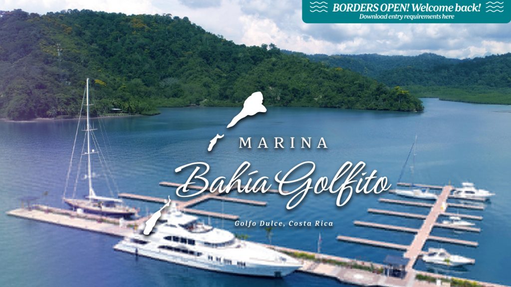
https://www.marinabahiagolfito.com/
SERVICE PROVIDERS
🇲🇽 Palenque
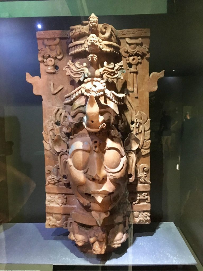
Palenque also anciently known as Lakamha "Big Water" , was a Maya city state in southern Mexico that flourished in the 7th century. The Palenque ruins date from ca. 226 BC to ca. 799 AD. After its decline, it was overgrown by the jungle of cedar, mahogany, and sapodilla trees, but has since been excavated and restored with an onsite museum. It is located near the Usumacinta River in the Mexican state of Chiapas resides at 150 meters (490 ft) above sea level.

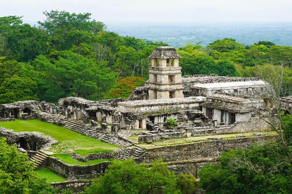
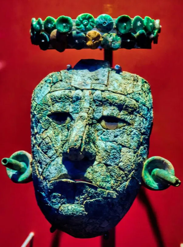
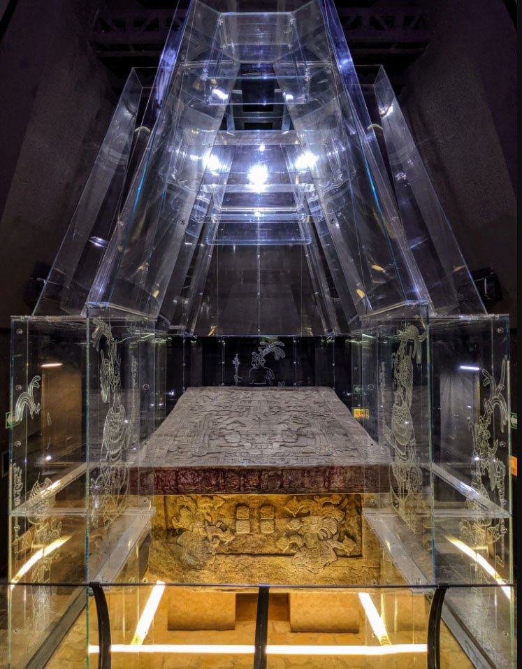
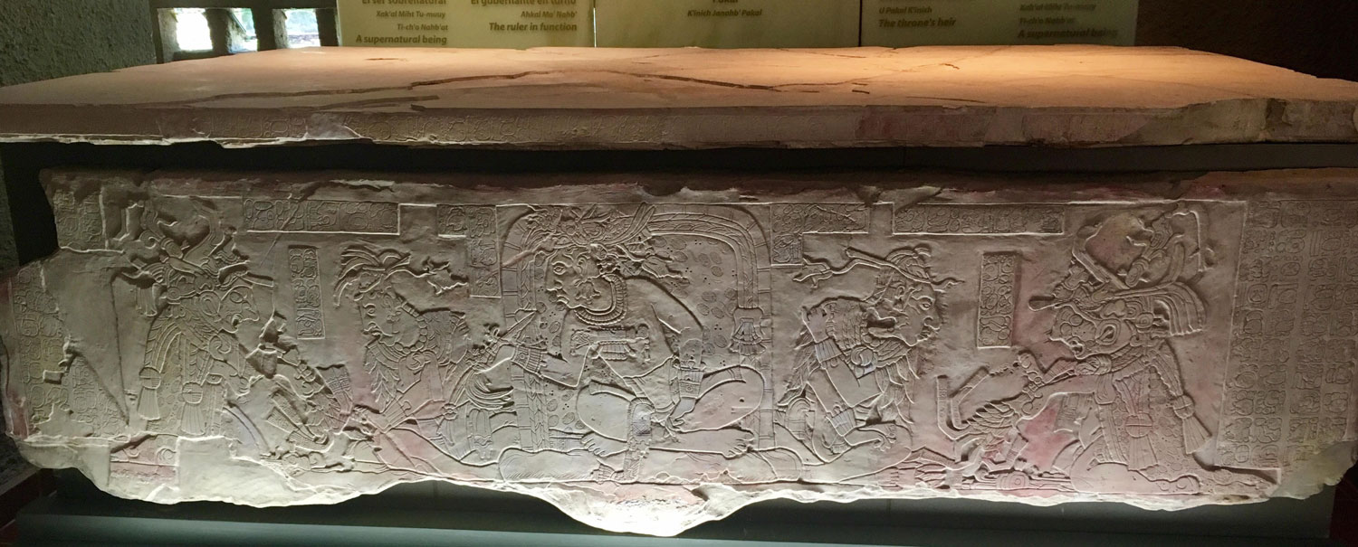
Palenque is a medium-sized site, smaller than Tikal but it contains some of the finest architecture, sculpture, roof comb and relief carvings that the Mayas produced. Much of the history of Palenque has been reconstructed from reading the hieroglyphic inscriptions on the many monuments; historians now have a long sequence of the ruling dynasty of Palenque in the 5th century and extensive knowledge of the city-state's rivalry with other states such as Calakmul and Toniná. The most famous ruler of Palenque was K'inich Janaab Pakal, or Pacal the Great, whose tomb has been found and excavated in the Temple of the Inscriptions. On the lid, as in his tomb, Pakal is positioned in an intermediary space, between the heavens—symbolized by the world tree and bird above him—and Xibalba, the Maya underworld. In addition to the remains of Pakal, precious materials such as jade, shells, pearls, and obsidians were discovered inside the sarcophagus.
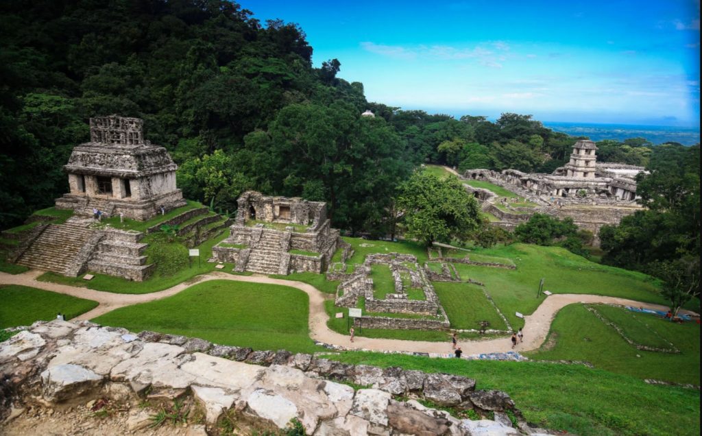
It is estimated that less than 10% of the total area of the city is explored, leaving more than a thousand structures still covered by jungle.
The first published account of this lost city was in 1567, from a Friar of the Dominican Order Pedro Lorenzo de la Nada. Lorenzo came upon its stone temples, terraces, plazas and architecture, originally decorated with blue- and red-painted stucco but by then long abandoned by the Maya who built it. Lorenzo gave the grand structure the name Palenque, a Spanish word meaning "fortification." As drought and warfare tore apart the social and political fabric of the Maya the Spanish conquistadors began claiming Maya land for plantations and subjugating Maya people to work on them, many residents of storied stone cities such as Yaxchilan and Palenque fled to the countryside in search of a better life. Ultimately they founded a host of new Maya cultures. Some people, known as the Lacandon Maya, established themselves in the forests around Lake Mensabak in the southern Mexican state of Chiapas. Their descendants still live in this region today. They are the Hach Winik, “the true people” in Yucatec Mayan.
The rulers of Palenque were called the "Holy Lord of Toktahn" or "Holy Lord of Baakal", and among the king list are several legendary leaders, including Snake Spine and Ch'a Ruler I. The very first named ruler of Palenque is GI, the First Father, said to have been born 3122 BCE, and the Ancestral Goddess said to have been born 3121 BCE.
The dynastic rulers of Palenque begin with Bahlum-Kuk or K'uk Balahm, the Quetzal Jaguar, who took the throne of Palenque in 431 AD.
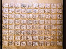
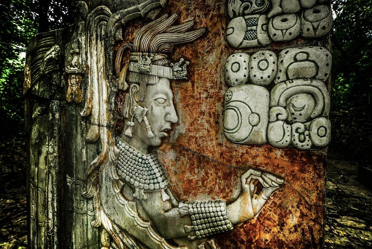
Lengthy Mayan texts, which researchers have used to translate Maya script.
![]()
16th century
The quest to decipher Maya hieroglyphs began with the very Spanish invaders whose rule did so much to wipe out the ancient Maya script. Among them was the conquistador Hernando Cortes, who led massacres in Mexico but who also, some scholars believe, had the famous Dresden Codex—one of just four Maya illustrated books surviving today—shipped back to Spain. Another was Diego de Landa, a friar bent on replacing indigenous with Christian beliefs. In what amounts to a crime against the cultural heritage of humanity, Landa orchestrated the burning in 1562 of hundreds if not thousands of Maya bark-paper books, which he deemed heretical. Yet four years later, Landa wrote a manuscript about the Maya world called "Relation of the Things of Yucatan" (left). Together, this manuscript and the Dresden Codex proved essential in the later decoding of the Maya's calendar system and their advanced understanding of astronomy and mathematics
1832
Counting
Actual decipherment began with an eccentric European genius named Constantine Rafinesque, who boasted of having dabbled in more than a dozen professions, from archeology to zoology. His insatiable thirst for knowledge had led Rafinesque to a reproduction of just five pages of the Dresden Codex, from which he was able to crack the Maya's system of counting. In 1832, Rafinesque declared in his newsletter, the Atlantic Journal and Friend of Knowledge, that the dots and bars seen in Maya glyphs (like these at left, from the Dresden Codex) represented simple numbers—a dot equaled one and a bar five. Later findings proved him right and also revealed that the Maya even had a symbol for zero, which appeared on Mesoamerican carvings as early as 36 B.C. (Zero didn't appear in Western Europe until the 12th century.)
1881
Photo documentation
Britain's Alfred Maudslay was a respected diplomat, but he would be best remembered for his work as an amateur Mayanist. Fascinated by scholars' writings on the Maya and by new advancements in photography, Maudslay set out to create as complete a record as possible of the civilization's architecture and art. Using a large-format, glass-plate camera, he captured highly detailed images of Maya sites, including clear close-ups of the glyphs (left). He also prepared papier-mâché casts of several carvings from which accurate drawings were later made. Maudslay had effectively given Maya studies its first systematic corpus, or body, of inscriptions. This helped make further decipherments possible, in part by bringing glyphs to scholars who had limited access to the few surviving Maya texts.
1952
The sounds of the glyphs
While glyph studies languished in the West, a Russian linguist in Moscow was making his own groundbreaking discoveries. In 1952, Yuri Knorosov (left) postulated that the individual symbols in Maya glyphs stood for phonetic sounds, much like English letters do. Knorosov knew that Maya had too many glyphs to be a true alphabet but too few for each glyph to symbolize an entire word. (Maya's 800-plus glyphs compare to the several thousand characters of Chinese, for example.) He determined that written Maya, like Egyptian hieroglyphics, contained a combination of these elements. Because "west," in spoken Maya, is "chik'in," and "k'in" is the word for sun, the hand represents the syllable "chi," as Knorosov concluded. Fortunately, American scholars Michael and Sophie Coe began publishing Knorosov's papers in the U.S. in the late 1950s. Otherwise, his important (though incomplete) findings might have been inaccessible to Western scholars until the end of the Cold War.
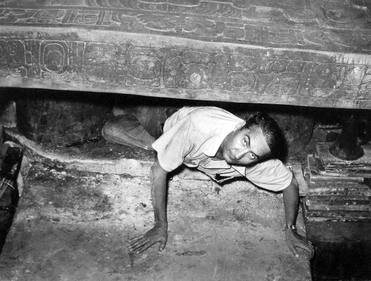
Tombraiders
Scientific debt is owned to the famed Mexican archaeologist Alberto Lhuillier, who in 1952 removed a stone inside the Temple of Inscriptions and found the burial tomb of Pakal the Great. This has since become one of the most extensively studied archaeological sites in the Americas.
500 years later this site is one of the most visited archaeological sites in Mexico with close to 1M visitors x year. Archeological researchers have uncovered some of the most detailed information about Maya culture
How to get there
Leave your vessel at Marina Chiapas on the Pacific coast ( entry and exit in Puerto Madero South Western Mexico) and drive to this site with a shared guided tour - or if you are adventurous drive yourself though Zapatista territory. Although the EZLN is still active and maintains a few strongholds in Chiapas, things are relatively peaceful and there is no threat to tourists. Travelers are advised to respect any roadblocks they may come across in rural areas which may require payment of an unofficial road tax. Get to the site early int he day before most day tourist show up and head to the Museum at mid day to avoid the crowds and chachki vendors inside the park which amass around 11 AM.
![]()
https://panamaposse.com/marina-chiapas
TO JOIN THE PANAMA POSSE WHICH FOCUSES ON FINDING INSPIRING DESTINATIONS FOR YOU AND YOUR VESSEL AS YOU
SIGN UP FOR THE PANAMA POSSE
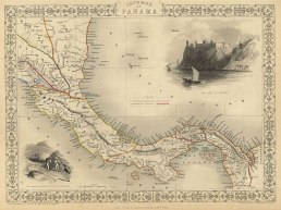
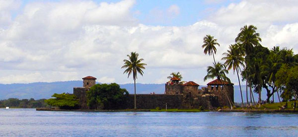
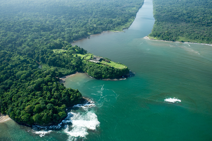
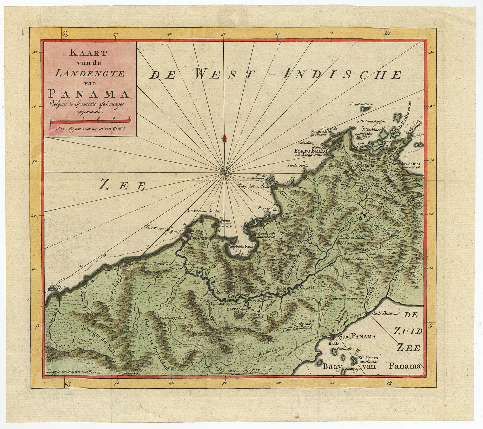
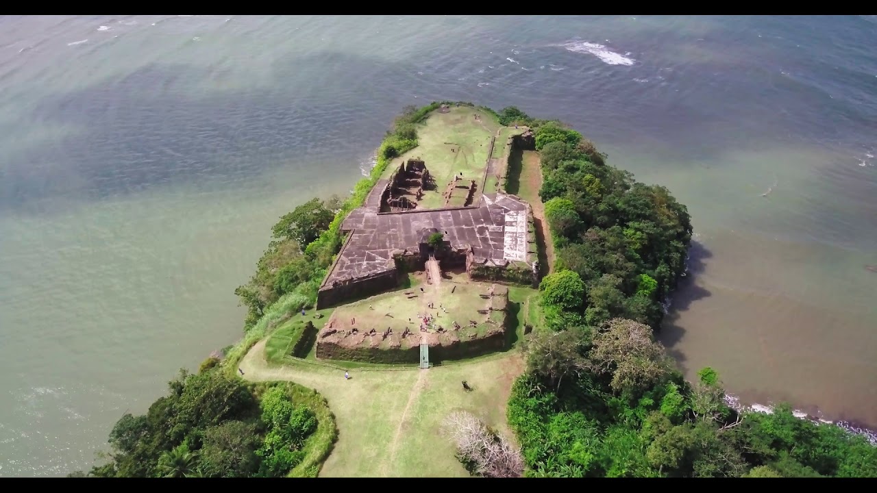
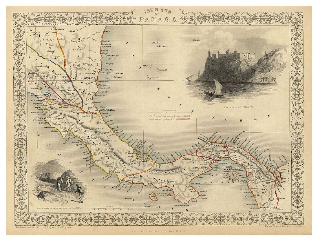
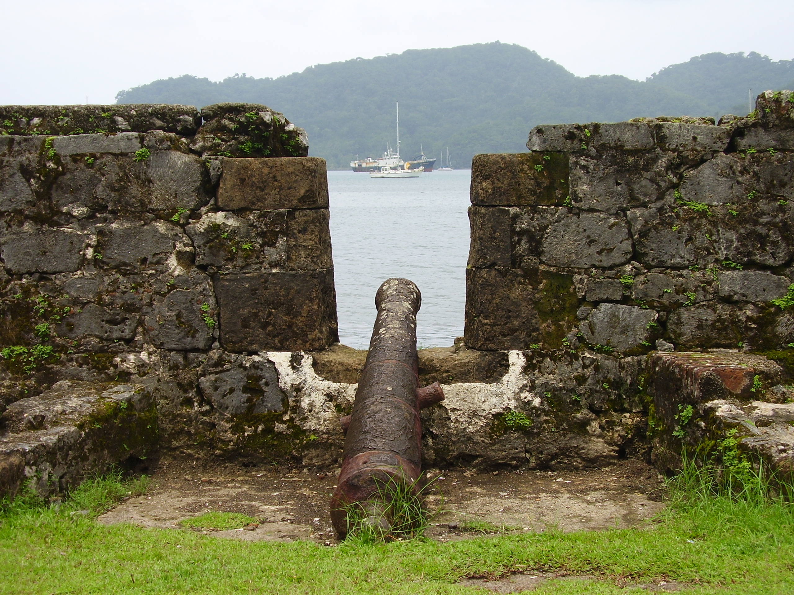
🇵🇦 Castle of San Lorenzo at Port Chagres
🇵🇦 Castle of San Lorenzo at Port Chagres, Panama
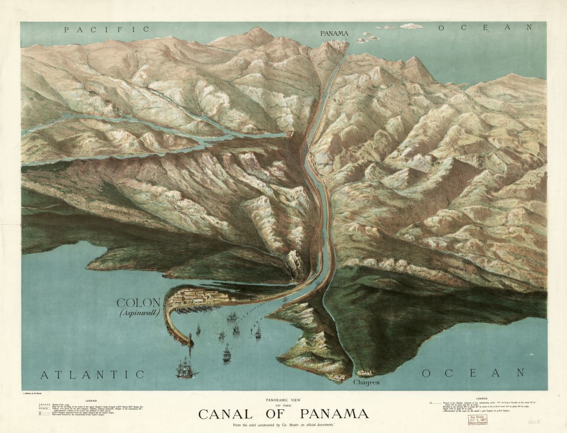
overlooks a bay leading into the river Chagres some 100 feet down a cliff. The river leads inland about 2/3 of the way across Panama to Panama City. A dam was built as part of the canal construction around 100 years ago. This created a big inland lake (Lake Gatun). The Panama Canal locks are used to lift boats up into this lake, sail across to the other side and then through a 7 mile long trench in the rock to the locks on the Pacific side where the boats go back down.
By 1534, the Monarchy of Spain had, following its conquest of Peru, established a rainy-season gold route over the isthmus of Panama —Camino Real de Cruces— using mule trains and the Chagres River.
The trail connected the Pacific port of Panama City to the mouth of the Chagres, from whence Peru's plunder would sail to Spain's storehouses in the leading Atlantic ports of the isthmus: Nombre de Dios, at first; and, later, Portobelo. The dry-season, overland route—the Camino Real—connected Panama City with those ports directly. Attracted to the treasure, pirates began attacking Panama's coast around 1560.
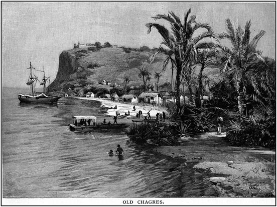
Captain Morgan the pirate came along about 300 years ago and captured the fort from the Spanish. He then took his boats and men inland as far as he could. He then found 500 mules and transported guns and canons and supplies another 7 miles to Panama City where he plundered all the gold for himself and men that the Spanish had plundered from local Indians. It is hard to tell who was the bad guy here.

Needles to say that most Spanish fortifications where built and maintained by indigenous, indentured or slave labor.
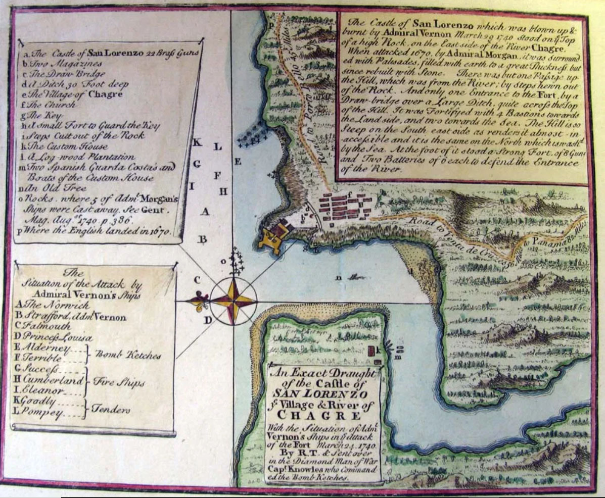
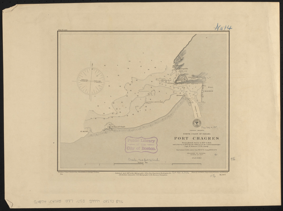
The Port of Chagres Chart
A design which did NOT work
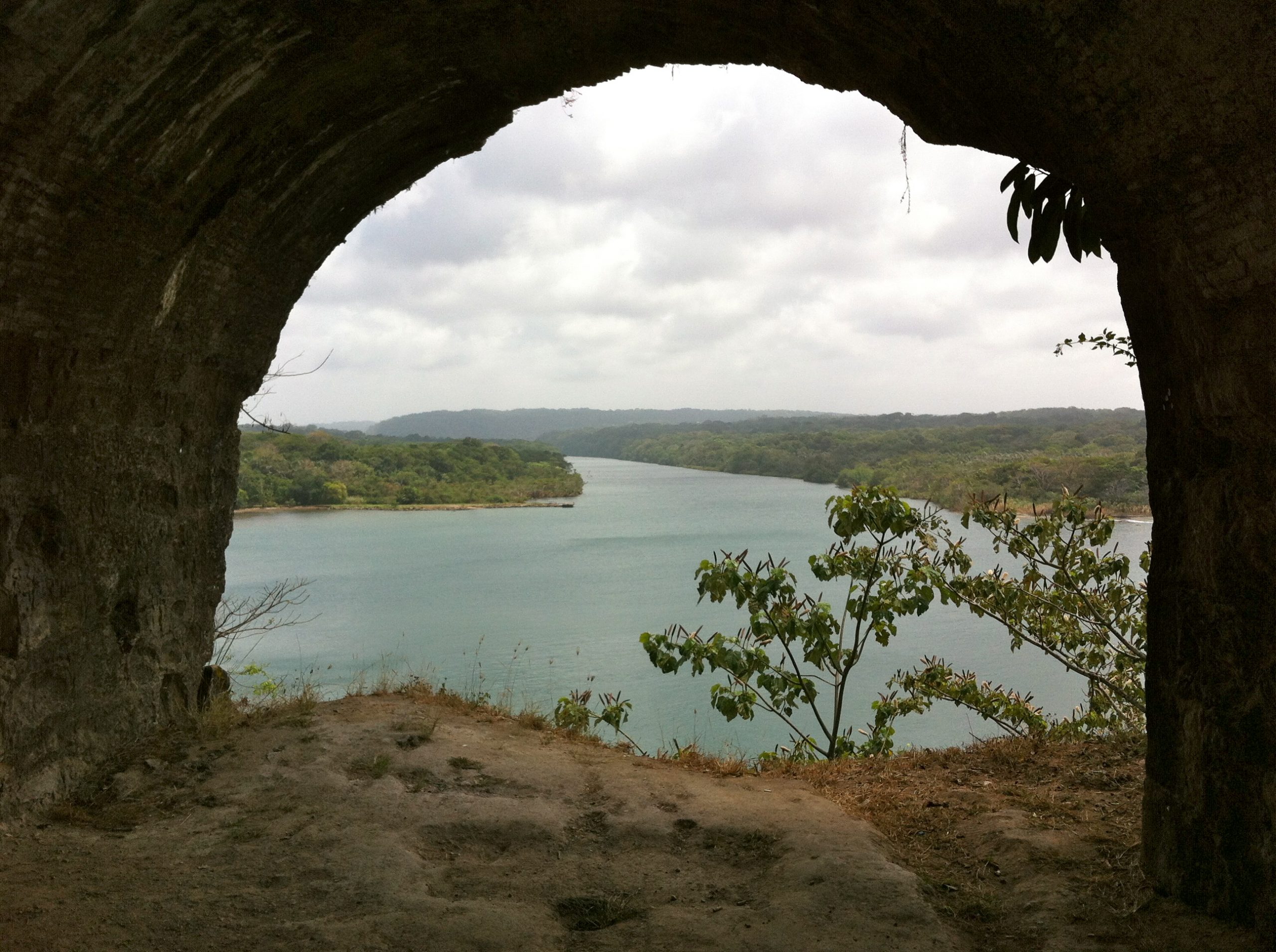
Fortifications overlooking the Chagres River
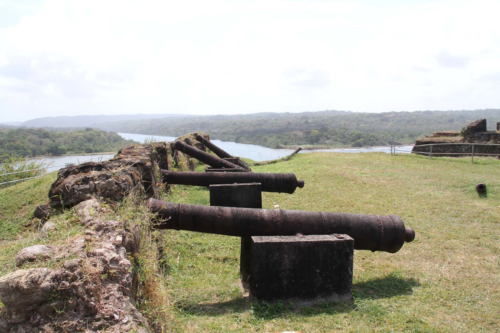
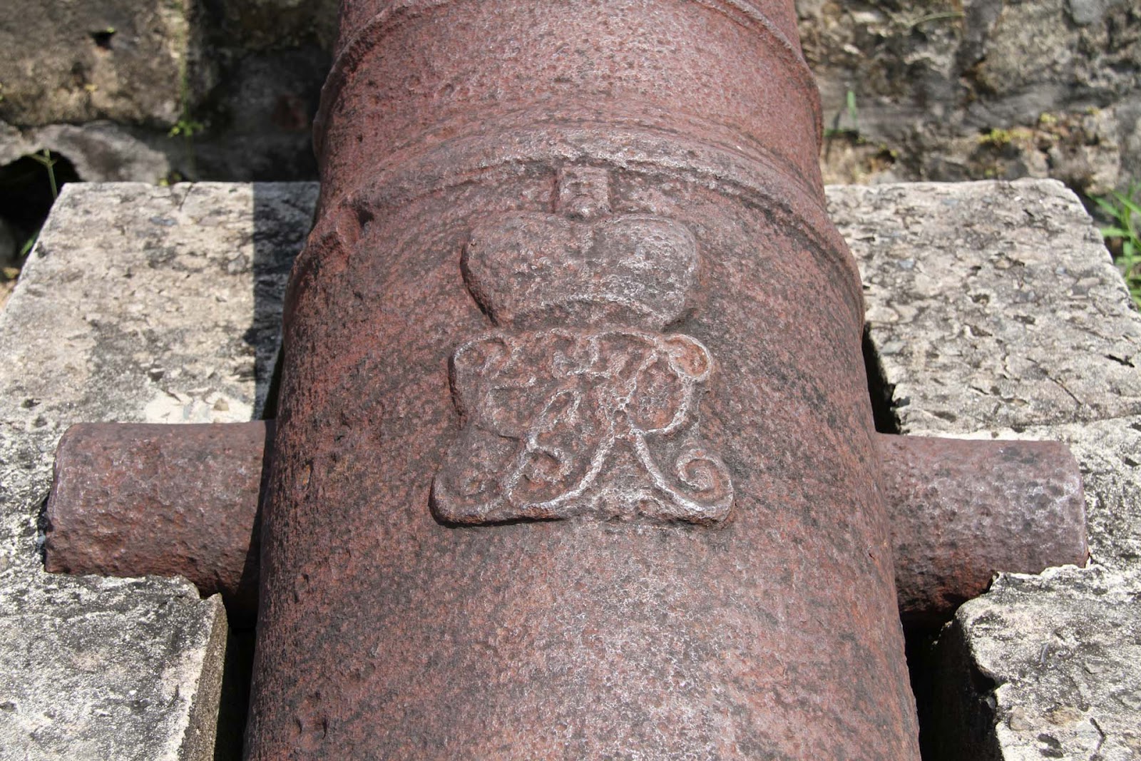
The Spanish Canons.
From a Sailing and engineering perspective there is an interesting connecting thread - We are focusing on the activities of Juan Bautista Antonelli and his brother.
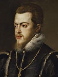
Battista Antonelli (or Bautista) (1547–1616) was a military engineer from a prestigious Italian family of military engineers in the service of the Habsburg monarchs of Austria and Spain (Philip II) worked with his older brother on projects in Oran, Algeria and Spain.
His works sometime with the help of his brother can easily be divided into two well-defined and different periods: in the first, from 1560 -1580 onward dedicated to fortifications and defenses on the Levantine coasts and ports of North Africa with his first fortification is in Cartagena de Levante dated 1562 and signed by him followed by Castillo de Santa Bárbara in Alicante, Peñiscola and the African ports of Oran and Mazalquivir.
In 1580 Felipe II occupied Portugal and incorporated it into his kingdom. It was a relatively quick military operation and without confrontations on the battlefields because the action was more of a peaceful occupation than a fought conquest. Felipe II commissioned Juan Bautista Antonelli to find solutions for the easy movement of the troops, prepare the roads and smooth the rough spots of the terrain to speed up the transfer of supplies, supplies and armaments. The topography, however, was rugged and rugged; bad roads and with various rough edges difficult to overcome. Hence the idea of river navigation and the conveniences it represented for the transfer of heavy equipment arose.
The second period of work in the Americas
In 1581 Antonelli was commissioned by the king to build a fortress along the Straits of Magellan ( utter failure), to protect this vital sea lane from attacks by English privateers. From 1582-1584 he designed and built the Castle at Fortaleza in Brazilian and in 1586 he was commissioned to build fortifications for the city of Cartagena in Colombia.
Using the latest military technology of the time, he designed the city's renowned defenses, the San Felipe de Barajas Castle, the San Sebastián de Pastelillo Fort and the San Fernando Fort. He then set sail for Havana. In Havana he designed the fortifications which culminate at the fortress of El Morro (Los Tres Reyes).
An finally he returned to Spain and even worked on the fortresses in Gibraltar.